Groundwater Resources
Find valuable information to support your groundwater program.
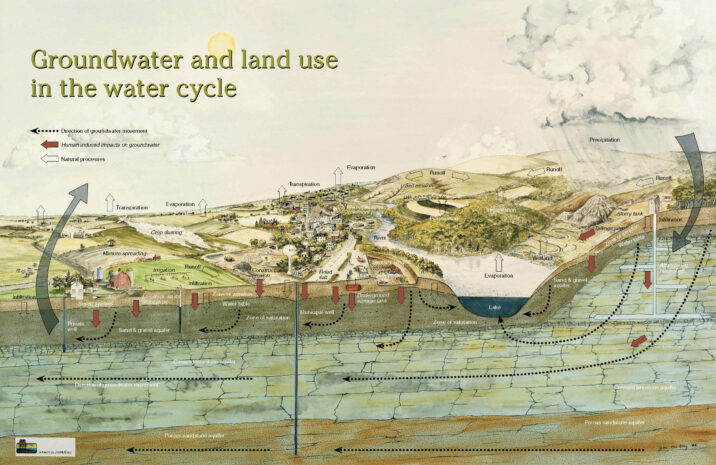
The following resources range from the fundamentals of how groundwater interacts with land use and statewide assessments, to localized trends and maps that illustrate how water flows within your county.
State Groundwater Quality Reports
GCC Report
Groundwater Coordinating Council's Report to the Legislature The Groundwater Coordinating Council prepares an annual report each year that summarizes the operations and activities of the council, describes the state of the groundwater resource and its management and makes recommendations.

Groundwater Quality Report
Wisconsin Groundwater Quality: Agricultural Chemicals in Wisconsin Groundwater report provides an overview of groundwater quality from the Department of Agriculture, the National Agricultural Statistics Service, and the Department of Health and Family Services.
Annual Drinking Water Report
The DNR's annual drinking water report and interactive map highlight efforts to help public water systems provide safe and adequate supplies of drinking water in our state.
Data and Mapping Viewers

Well Water Viewer
Visit the Well Water Viewer to explore and learn about the private well data already collected in your county or watershed.
Trends in Public Well
Visit this app to assess how water quality in public wells have changed over time.
Groundwater Quantity Viewer
View the locations and volumes of high capacity well and surface water withdrawals on an interactive map. View pending high capacity well applications and approved wells. View water quantity data measurement locations.

Atrazine Prohibition Areas
Visit the interactive viewer to find the approximate boundaries of atrazine prohibition areas in Wisconsin.
Surface Water Data Viewer
FINDING WELLHEAD PROTECTION AREAS IN SURFACE WATER DATA VIEWER
Looking to figure out the approximate 5 year zone of contribution for a public well? Whether deciding to include as a "critical area" in your 9 Key Element Plan or to help assess land use practices that might rehabilitate a well, visit the Wisconsin Department of Natural Resources' (DNR) Surface Water Data Viewer.
- Launch the Viewer
- Zoom into area of interest
- Click on Show Layers and scroll down to check the box for Permits and Determination
- Check the box for Source Water Protection Areas
Some municipal wells may have a modeled boundary, while other, smaller public wells have a standard circle boundary around the well.
If you're assessing small public wells or private wells, use a water table map that can be found at Wisconsin Geological and Natural History Survey (WGNHS) to understand the direction groundwater is traveling.
Launch SWDV